
However, the drawback of this “time taking approach” is that it is reactive—we have to wait longer for data collection and processing in order to plan the next move. In a high-traffic situation, only several days are needed to collect enough data required for analysis.
Here drone technolgy can make a huge difference. Instead of analyzing over line drawings and elevations in CAD, a more proactive approach is to analyze 3D data with complete aerial analytics. A key advantage of thinking about aerial analytics rather than drawing is that they are highly detailed and can be produced in a quick time, making it possible to conduct studies and planning in a much shorter time span.
With all the recent successes of machine learning techniques UAVs are not so behind in solving many complex tasks. Machine learning from raw sensor data has created a lot of excitement in the UAV industry. In fact, many declared Infrastructure sector primed for UAV and Machine learning.
In our recent project, we have grouped UAV data and Machine learning to map a busy junction in Kerala, which is a proposed site for a flyover construction consistent with the usual heavy traffic. The purpose of referring to this method to achieve a better understanding of the nature of the outputs that can be produced to the construction, engineering, and architectural workforce.
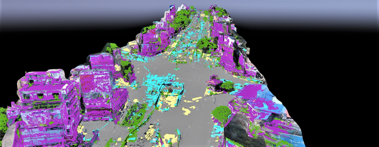
Using this method also helps identify the components in which deep learning has not been applied yet. With more than 500 aerial imagery in hand, the Aerizone team worked through the night to process the data and generated the initial ray-cloud with an RMS value less than 2mm. Here are some of the results.
The point cloud data was generated and optimized using Trimble DGPS data with an overall accuracy of 2cm. Generating a point cloud can be considered as the most important step in the development of automated feature-detection algorithms using techniques from UAV sensors, computer vision, and machine learning.
The main objective we want automated solutions is because aerial imagery already presents a Big Data challenge. A single UAV flight can generate hundreds of images. It needs a skilled UAV data analyst many hours to analyze imagery captured from just one 30 minutes of flight time.
Because of this flexibility, more cities should turn to UAV analysis as a way to measure and assess road and Infra projects. With the ability of Machine Learning in UAV data, even heavily congested infrastructures can be analyzed in a much more effective manner in many third party GIS and CAD software.
However, Unmanned aircraft systems still have several limitations, restricting weight, span, power consumption of the payload. These limitations are mainly due to the current state of sensor and battery technology. which ultimately limits the required capabilities for autonomous operations. We are still working on improvement in these areas in the forthcoming years for more capable data collection UAVs.